Return to Mooningwanekaaning

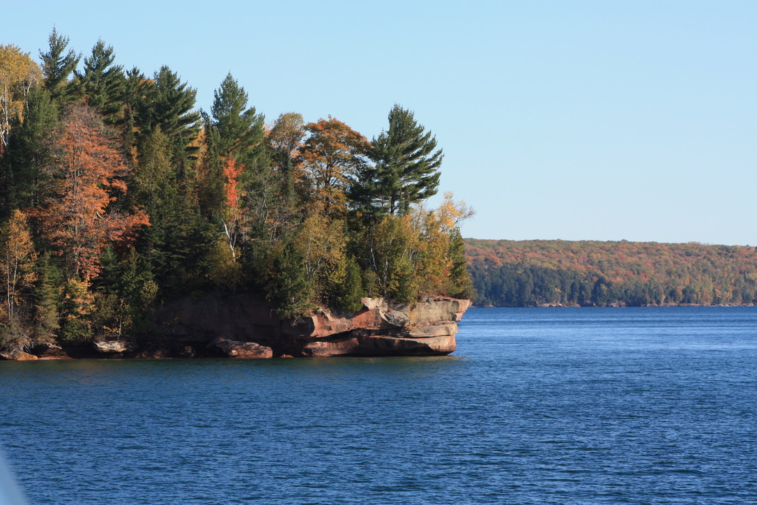
Last October, my wife and I decided to make trip back to Madeline Island to celebrate our anniversary. We had been there several years ago and really enjoyed our time there. I also wanted to go back because the Madeline Island Museum was closed last time and I wanted to see if they had any information about my ancestors.

We stayed in Bayfield and took the ferry out to LaPointe. The museum was open this time. I told a staffer at the front desk that my great-great-great grandparents were married there. She offered to make photocopies of pages from the marriage register, which had been compiled and typed from the original register. I got a copy of the page listing the marriage of Pierre Trotochaud to Angelique Masset (or Massey) by Father Baraga in 1843. Interestingly, Angelique was listed by her mother’s maiden name and not Blair.

While touring the museum, I stopped to talk with an elder from the nearby Red Cliff Reservation named Rob who worked there. I told Rob about the marriage record. He said the names sounded familiar to him. Then he showed me a photo of a book on his phone, “All Our Relations”. Rob suggested I check it out to see if I could learn more about my family.

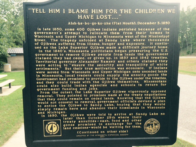
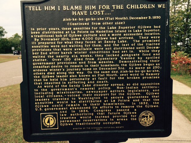
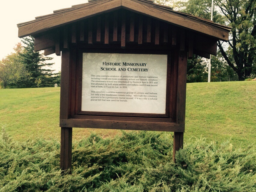
Rob went on to tell me about the importance of the island (called Mooningwanekaaning in Ojibwe, referring to home of the yellow-shafted flicker) to the Ojibwe. He told me that many of the people who migrated from the island to Sandy Lake, where Angelique was from, were of the Loon Clan. Rob explained that, although the Ojibwe had dispersed from Mooningwanekaaning to reservations established by the treaties, they still considered the island their spiritual home. Rob pointed out that many of Catholic Indians continued to return to the island to have their children baptized and to be married. He mentioned two children buried at the Catholic church who perished at Sandy Lake and their parents buried them at LaPointe. (These were Clem Beaulieu’s two daughters who died in 1845.) I enjoyed my visit with Rob and told him I hoped to see him again.

When I got home I immediately reserved a copy of “All Our Relations” from the local library. Rob was right: the book had information about our family. The book includes records of interviews conducted at LaPointe after the Treaty of 1837. The government was trying to determine who was eligible for a payment to mixed bloods that was provided for in the treaty.

One of the interviewees was Margaret Bles (Blai or Blais), who was born at Pine River in Iowa Territory, which at that time included most of what is now Minnesota. She had resided at Sandy Lake “until within the last 2 months.” The entry went on to say that she married a man named Alexis Bles “13 or 14 years since”, which would be about 1825. The marriage produced 5 children: Angelique, 11 yrs old; Antoine 10; Joseph 8; Edouard 6; and Alexander 4. Antoine had been born at Mille Lacs and Joseph at Leech Lake; the other three children were born at or near Sandy Lake. This record matches the names and approximate ages of the Blairs in our family tree. The record also mentions that Alexis had died “4 years since.” This would be about 1835.

The book also includes information about a man named Alexis Blais who appeared before the Indian agent in 1828. He was one of three men who were ordered out of Indian country the previous year because they did not have licenses to trade in Indian country. The men were summoned to Sault Ste. Marie by the agent, none other than Henry Rowe Schoolcraft, the “discoverer” of the Mississippi headwaters. The episode is documented in Schoolcraft’s “Personal Memoirs”, which includes parts of his daily journals. Schoolcraft wrote that Alexis “pleaded ignorance” to the laws pertaining to traders and Indian country. Schoolcraft’s journal implies that Alexis was the subject of a complaint by “Mr. Aikin” at Sandy Lake. That would be William Aitkin, the trader who ran the American Fur Company post there. During the interview, Alexis guessed that he would not have gotten in trouble if he had worked for Aitkin instead of independently. According to Schoolcraft, Alexis “did not desire to return to the Indian country”.

If Alexis Blais did leave the area in 1828, he would not have fathered Margaret’s younger children. In her interview at LaPointe Margaret claimed he died around 1835, which suggests he did not leave after meeting with Schoolcraft but returned to his family.

This experience has finally cleared up the mystery of who Alexis Blais (Alexander Blair) was and gives me a better picture of what life was like for Margaret and her children. It appears they moved wherever Alexis could make a living, with stops at Leech Lake and Mille Lacs. It is fascinating to to know that our ancestors interacted with historic figures like Schoolcraft, Baraga and Aitkin.

Mooningwanekaaning was important to the family; Margaret and her children were baptized there by Father Baraga later in 1839 (documented in “All Our Relations”). Now the island holds a special place in my heart, too.

Prosperity and Hard Times in Callaway

I have been studying this photo for quite awhile because I think it tells a story.

Spry family home

The photo appears to have been made around 1900. Mitchell and Amelia had been working their farm for about 25 years. In that time, they had managed to build a relatively large, well-appointed home complete with window shutters and landscaping.

The way his family is posed in front of his house suggests that Mitchell wanted to show the world he was prospering. He had come along way from his poor beginnings in Quebec. His family looks healthy and well-clothed. This was no snapshot; the photographer composed the photo carefully. The message is clear: this family is successful.

We do not know much more about Mitchell and Amelia’s life. We know that Mitchell and Amelia served on committees organizing the White Earth Celebration back in 1888, according to the The Progress, White Earth’s newspaper. We know Mitchell was one of five men who signed (Mitchell with an X) for a 90-day note for $700 for construction of the Catholic church in Callaway in 1909 (from Assumption Catholic Church’s centennial booklet).

One other source of information on the family is the Becker County Recorder’s office. These records indicate Mitchell and Amelia mortgaged the farm in 1907 and satisfied that debt in 1908. The deed records include several entries indicating the Sprys, including sons Henry and Peter, may have been speculating on lots in the newly platted town of Callaway. Callaway sprung up on a former Indian allotment along the Soo Line railroad, about 3 miles from the Spry farm. Henry and his brother-in-law Eusebe obtained a “town lot deed” in 1908 from Tri-State Land Co. for a lot in Callaway; this may have been where they established their store.

The deed records indicate Pete and his wife Addie sold Pete’s original 80-acre allotment along the Buffalo River to Annie Reinhardt, wife of Henry who owned the flour mill in Richwood. Presumably, Pete then farmed with Mitchell and his brothers for a time. In 1917, Pete and Addie bought Mitchell and Amelia’s farm with $1500 in financing from his parents and another $500 borrowed from his brother Henry. Pete and Addie raised their ten kids on this farm.

That same year, the U.S. entered World War I. Farm prices grew stronger during the war, as demand increased to feed war-torn Europe and the hungry soldiers overseas. Wheat prices increased from $1.03 per bushel in 1914 to $2.34 in 1919, according to the Minnesota Historical Society. Land prices also doubled in value, and farmers found it relatively easy to obtaining financing to expand their operations.

In 1920, Pete and Addie obtained a $4000 mortgage from Security State Bank in Detroit Lakes and a $300 second mortgage from Citizens State Bank in Callaway. They used these funds to pay off their debts to Pete’s parents and brother.

After the war ended and as European countries began to recover, crop surpluses began to build. Burdened with debt, farmers were reluctant to reduce production and crop prices began to drop. By 1920, wheat was down to $1.65 per bushel. With reduced demand, land prices also declined. Soon, farmers were unable to make their mortgage payments. Between 1926 and 1932, foreclosures took 1,442 farms in Minnesota. The farm crisis also precipitated bank failures, including Security State Bank and Citizens State Bank.

In 1924, Pete and Addie obtained a $6000 mortgage from the State of Minnesota. This mortgage may have been issued by the Department of Rural Credit, formed by the state in response to bank failures. The couple apparently used this financing to satisfy the previous mortgages, which were then held by Northwestern Trust Company.

In 1927, the State of Minnesota foreclosed on Pete and Addie. A sheriff’s sale was held on June 11, 1927. It does not appear that there were any successful bidders, as the 1929 county atlas still listed the State of Minnesota as the owner of the farm and the 1930 census indicated they were renting the farm. The home Mitchell and Amelia built and were so proud of was still home for Pete and Addy, but it was not theirs anymore.

Another photo of the Mitchell Spry family, taken around 1920, tells another story.

Mitchell Spry Family

Back: Eliza Spry Bellefeuille, Amelia Spry Bellefeuille, Lawrence Spry, Madeline Spry Trepp, Ellen Spry Bowman. Front: Henry Spry, Mitchell Spry, Amelia Trotochaud Spry, Frank Spry. Missing: Peter Spry

Here the adult children surround Mitchell and Amelia, perhaps on the occasion of their 50th wedding anniversary. Again, this portrait depicts a prosperous family. But Peter is not in the portrait. According to family lore, he was too busy working in the fields to sit in on the photo. This story suggests that Pete did not lose the farm for lack of effort.

The 1940 census indicates Pete and Addie had moved into Callaway sometime after 1935. Pete served as city treasurer and also served on the school board. Oldest son Ray, his wife Abby and their kids Russell and Donna were staying with Pete and Addie in 1940. The youngest boys, Lee and Bunt, were still living at home. Soon they would be off serving in World War II. Elmer would serve, too.

The 1940 census has Uncles Ernie and Elmer living in Grand Portage. Uncle Ernie joined the Civilian Conservation Corps and helped build the replica trading post at Grand Portage. A historian researching the CCC in Minnesota interviewed Ernie in 1982 about growing up during the Depression. He recalled the whole family out picking potatoes in farmers’ fields for $3 a day.

Pete and Addie’s oldest daughter Ethelbert had married Lauren Brandvig of Nebraska and was living in Minneapolis and working at Woolworth’s (1937). Doris had married Joe Zurn; Joe was a truck driver who owned his own truck in 1940. Rena was married to Dan Clark, who was working for the Works Progress Administration (WPA), which was building roads and public buildings. Lenora was married to Lyle Bryngelson, who worked for Cass-Clay Creamery; they were living in Moorhead in 1936. Lenora’s twin, Leonard “Bud” Spry was my grandpa. In 1940, he and wife Irene (Diz) and my dad Jerry lived in Callaway and Bud worked at Paul Johnson’s bee farm.

Spry sisters

Rena, Doris, Ethelbert and Lenora Spry, daughters of Pete and Addie

L to R_ Ervin, Elmer, Lee
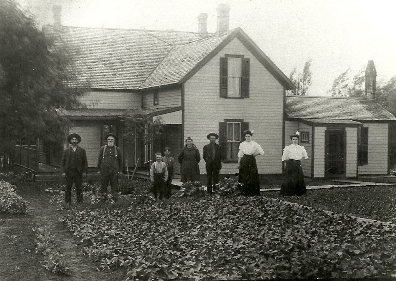
Despite a disastrous farm economy and the Great Depression, Pete and Addie managed to raise their kids and send them off into the world to start their own families. Pete lost Addie in 1944 at the age of 65. Pete lived the rest of his life in Callaway in a house on the south side of town. He passed away in 1971, at the age of 88.

********

In 1982, I came home to Callaway on Spring Break and helped my dad tear down Great-Grandpa Pete’s house to make room for a new house to be built by cousin Ernie Clark. I remember working alone in the old house, knocking out plaster walls and taking out studs that Dad would recycle for other projects. I remember finding a report card in one wall; it was Henry’s from his time at Carlisle Indian School. I gave it to Aunt Rena for safekeeping. As I worked, I wondered about Grandpa Pete. I couldn’t say I really knew him; I was 10 when he passed away.

As I said in an earlier post, the Sprys did not have a lot of stories about their ancestors. Researching my family history has filled in some holes in our story. Although I did not find a lot of details, I was able to align the facts I could find with events in the history of White Earth and of Minnesota. This gave me a better idea of what our ancestors experienced. Hopefully, our family now has a better sense of where we come from.

What I Learned at the National Archives, Chicago

IMG_0043

The “Bean” at Millenium Park, Chicago

There was still snow on the ground and ice on the lake in the last week of April when I traveled to Chicago to do some research for my book project. Although I had planned the trip to gather information for that project, I knew it would also be an opportunity to research our family’s history further. The Chicago unit of the National Archives holds records for the midwestern U.S., including Bureau of Indian Affairs records for White Earth and other reservations.

I spent an entire day at the Archives, and was able to access official correspondence to the Indian agent at White Earth as far back as the 1870s. I found the official record showing that Amelia Trotochaud Spry had “proved up” her land on the reservation prior to the allotment era. This process was spelled out in the 1867 treaty, whereby tribal members could claim 40 acres by breaking ground on 10 acres. Up to 160 acres could be claimed this way.  The record book had a total of 71 entries; Amelia’s 160-acre claim was 15th in the list, with the date of August 18, 1878. The location has the same legal description as the allotment she received under the Nelson Act of 1889. (In Amelia’s case the allotment was a formality.)

The Archives have the original receipt book kept by the Indian agent to record annuity goods handed out to tribal members. I found an entry dated August 8, 1874 for receipt of 11 lbs. of pork, 49 lbs. of flour and 10 lbs. of sugar issued to Angelique Blair (Mrs. Pierre Trotochaud). A week later, another entry had 4.5 lbs. of pork and 24.5 lbs. of flour being issued to Mitchell Spry. As these were the only entries in the book for members of our family, it suggests they needed some initial supplies when they got to White Earth. This means the Trotochauds and Sprys at White Earth in late July or early August of 1874. Amelia was about 5 months pregnant with Liza; Frank was 3 years old and Henry about 18 months.

The Archives also hold the original annuity rolls, which were used to record membership in the tribe. The members are listed under their respective chiefs; The Trotochauds and Sprys are listed under “O-muck-kuck-keence”. Interestingly, John Johnson Sr. is listed under the same chief. This could be Enmegabowh, the famous Episcopalian missionary. If so, it begs the question what if any relationship our family may have had with him.

The annuity rolls list all of the eligible children of each tribal member. These records appear to be at least as accurate as the census records in terms of names and ages. However, they reveal the names of additional children born to Amelia and Mitchell. The 1881 roll lists Josephine, born that year. The 1898 roll lists Matilda, age 3 but notes that she died in 1897. I seem to recall seeing a grave marker for her at Calvary Cemetery near the old mission.

The rolls also list Albert, born in 1886. He is listed in all of the rolls I reviewed up to 1898. He is also listed in all the censuses up to 1901, when he would have been 15. Then he disappears. Could he have run away? Or had a tragic accident? I did a search for Albert Spry on newspapers.com and found incidences of that name in papers throughout the country. Many were from the East Coast and were likely associated with the English name Spry. His name does not show up in any Minnesota newspapers. There were several references to an Albert Spry, an electrician in Arizona, who was convicted of larceny. Because other Spry cousins moved to Arizona to work in the mines, this could be a match for our Albert. However, this Albert, while the right age, claimed to have been born in California. Our Albert will remain a mystery, at least for now.

Finally, the Archives provide records of the additional allotments made to tribal members at White Earth as a result of the 1904 Steenerson Act. This act allowed all members who previously had only received 80 acres under the original Nelson Act to obtain another 80. The records show that my great-grandfather Peter, who had 80 acres next to Henry east of Callaway, selected an additional 80 acres about 2 miles east of Waubun. Youngest brother Lawrence selected 80 acres north of Ogema. Sisters Ellen and Madeleine selected land northwest of Ogema. All of these parcels appear to have been prairie that could be converted to farmland. Their sister Amelia received an allotment south of Big Sugarbush Lake. This was likely hardwood forest at the time, although about half of this parcel is now cleared and farmed. The allotment records are numbered, presumably in chronological order. All of these allotments issued to Sprys were numbered between 983 and 990. Because these parcels were far flung from their original allotments, it seems likely the Spry siblings rented them out or sold them.

Oldest sister Eliza, at that time married to Eusebe Bellefeuille, received additional allotment no. 225, which could mean she was in line on the day back 1905 when the government started issuing allotments (see my previous post). This parcel was located northeast of Waubun and was probably a mix of oak woods and prairie. Because these parcels were far flung from their original allotments, it seems likely the Spry siblings rented them out or sold them.

Among the records in the Archives I came across an affadavit signed by Peter (brother Henry was the second witness but his signature is absent) on behalf of “Zephine” Bellefeuille. Presumably this was Zephyr, his brother-in-law.This affadavit verified that Zephyr was a mixed-blood tribal member and was required to be submitted as part of an application for fee-simple patent for his additional allotment.  This was usually a preliminary step to selling the land. Based on the legal description, the additional allotment no. 261 received by Zephyr was located just west of Bad Medicine Lake. This was very likely pine land. Other Bellefeuilles and some Trotochauds also received additional allotments on the pine lands in the eastern part of the reservation.

IMG_0049
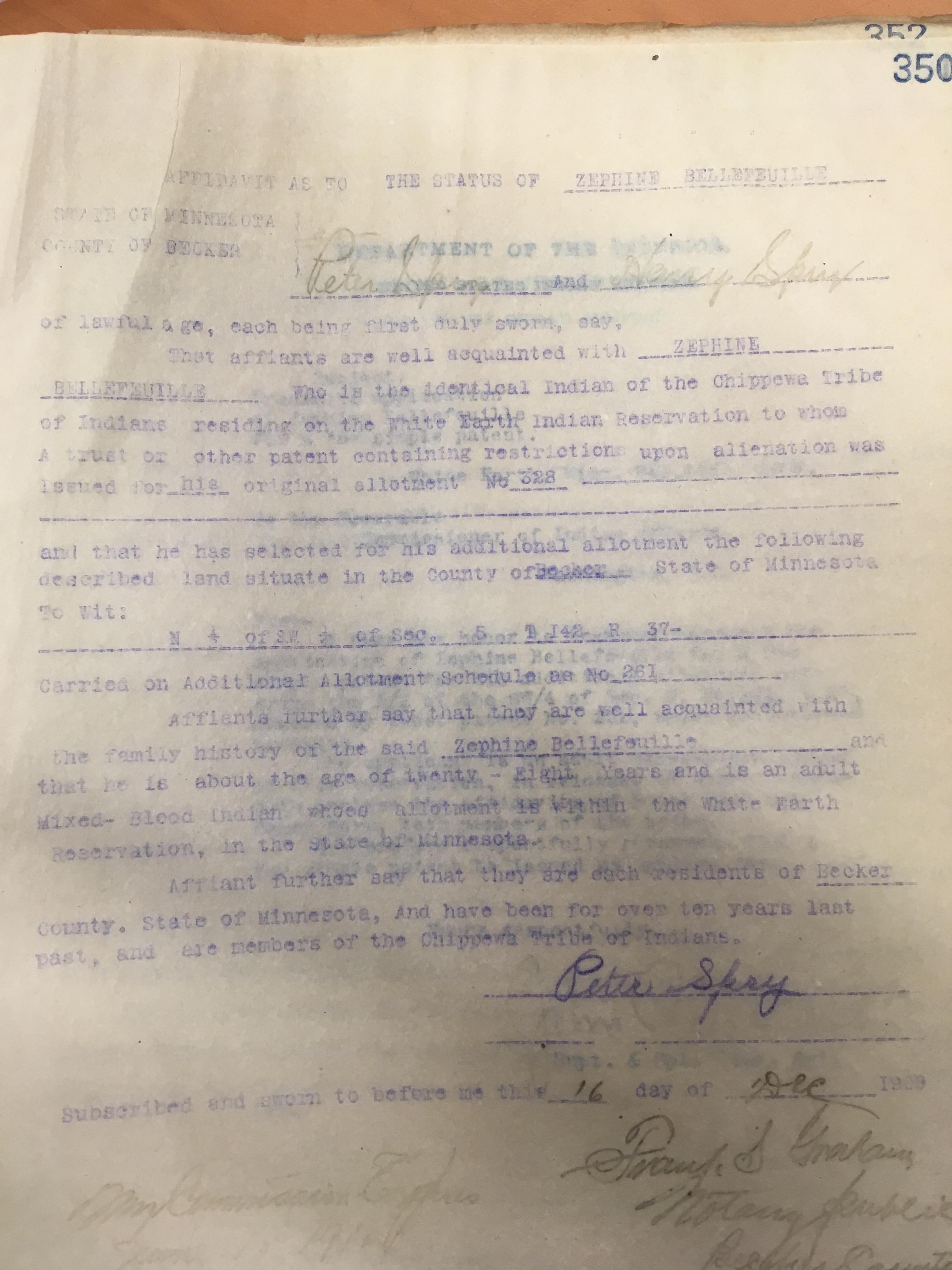
Finally, I reviewed records associated with the land fraud claims and investigations made at White Earth in the early 1900s. I came across a record (case no. 145) wherein Lawrence Spry mortgaged his additional allotment in 1909 for $800 to the Homestead Real Estate Loan Co. It is not clear whether this was proven to be a case of fraud (Lawrence was 18 or 19 at the time).

My time at the National Archives gave me a glimpse into some details of our family history. The records confirm the Sprys did not benefit from the scandals related to the pine lands. Their focus seemed to be on farming. Nevertheless, they were witness to major changes on the reservation in the late 1800s and early 1900s.


“A Model Reservation”

Callaway TWP

When we last visited Mitchell and Amelia Trotochaud Spry, they were settled on a farm in the southern part of the White Earth reservation. Amelia’s parents Pierre and Angeline settled nearby on land north of Richwood. Amelia’s siblings married into other early families at White Earth, with names including McDougall, LaDoux, Blue, Vizenor, Pelland, Roy and Fairbanks.

The earliest histories of White Earth describe it as a thriving community and a success story, at least from the government’s perspective.  In fact, prominent leaders in Minnesota like Henry Rice were advocating the relocation of all the Ojibwe in Minnesota to White Earth. These designs were as much about getting at reservation land as they were about “civilizing” the Indians. The lumber companies in St. Paul were clamoring for access to virgin timber on the reservations. Meanwhile, the rapid settlement of the Red River Valley to the west had created demand for opening up the western parts of the White Earth and Red Lake reservations to create more cropland for whites.

In 1889, Minnesota Congressman Knute Nelson sponsored legislation to consolidate all the Ojibwe at White Earth and assign 160-acre allotments (first authorized by the Dawes Act of 1887) to individual Indians. The intent of the law was to allow homesteading of “excess” lands by white settlers. But even before the excess lands could be sold off, the allotment process was corrupted. Rules were changed, enabling whites and mixed-bloods with little or no connection to the bands at White Earth to claim allotments. This story has been documented in a book, The White Earth Tragedy by Melissa Meyer.

Among those who benefited were the Beaulieus, headed by Clement H. Beaulieu, the oldest son of Bazil Beaulieu, an old trader from LaPointe. Clem’s mother was a Lake Superior Ojibwe, and her son used the extensive connections of both his parents to build a thriving trading business in Crow Wing. Clem Beaulieu’s sister Margaret had married Martin Bisson, another French-Canadian trader. They had been among the first families to homestead at Belle Prairie, a community a few miles downriver from Crow Wing. The Bissons migrated back to Quebec during the Civil War years; when they came back, they brought two sons-in-law with them. One was Theodore Bellefeuille, who married Sophie Bisson in 1855. Theodore and Sophie settled at Belle Prairie and began raising a large family. Theodore’s brother Raphael also settled there.

As descendants of Lake Superior Ojibwe, the Beaulieus were not eligible for allotments at White Earth. But Clem Beaulieu successfully argued that he and his family became eligible when the 1854 treaty with the Lake Superior Ojibwe allowed band members living at Sandy Lake and Crow Wing to switch bands. Under this arrangement, the Beaulieus and their relatives, including the Bellefeuilles became eligible to receive allotments at White Earth.

Theodore and Sophie Bellefeuille moved to White Earth and claimed an allotment not far from Mitchell and Amelia Spry. Two Bellefeuille sons, Antoine and George, who had married and started families, also moved to White Earth. The Bellefeuilles and Sprys, being neighbors and sharing a French-Canadian cultural background, became close and several marriages between the families occurred. Another son of Theodore and Sophie,  Eusebe, married Lizzie Spry, Mitchell and Amelia’s oldest daughter in 1891. Lizzie’s brother Henry married Eusebe’s little sister Georgiana. Bellefeuille cousins, children of Raphael, also married Spry siblings: Josephene married Frank and Jonas married Amelia. Finally, in 1905, Peter Spry, my great-grandfather, married Adelaide, the daughter of Antoine and granddaughter of Theodore. All of the Bellefeuilles (over 40 individuals) received allotments. Early applicants received 160 acres each; beginning in 1891 the government reduced the allotment size to 80 acres.

Meanwhile, other developments at White Earth were leading to more Indians losing their land to whites. In 1902, Congress passed a law allowing Indian heirs to sell allotments they had inherited. In 1904, the so-called Clapp Rider enabled tribal members to sell timber from their allotments. Also in 1904, the Steenerson Act was passed to allow allottees who only received 80 acres to claim another 80. The two laws, passed a week apart, opened the doors to speculators and lumber companies.

The day before the additional allotments were to be made in the spring of 1905, people lined up outside the agency. Many had prepared by scouting out locations where there was merchantable timber.  Ojibwe descendants from all over the country came in hopes of acquiring valuable property. The “full-blood” Indians protested and attempts were made to give them an equal chance by forming a second line. But the net result was most of the choice pine lands being awarded to mixed-bloods of certain families who were connected to the lumber companies. When the full-bloods complained, government officials said the mixed-bloods had shown initiative and demonstrated they were adapting to the white world. The full-bloods were dismissed as lazy.

Were any of our relatives in line that day? The Minnesota Historical Society has a Becker County plat book dating from 1911 that shows several Sprys, Bellefeuilles and Trotochauds owning parcels east of White Earth in the forested part of the reservation. These allotments may have been selected for these family members, some of whom were children, by relatives or unrelated brokers. Most of these tracts were located around Big Sugarbush and Strawberry Lakes, which was dominated by hardwood forest with few pines. By 1911, the lumber companies had already acquired most of the valuable pine lands further east.

The government further eroded the Ojibwe land base in 1906 when a second Clapp Rider passed, allowing mixed-bloods to sell their allotments outright. Wanting to share in the bounty, full-bloods signed affidavits claiming they were mixed bloods so they could sell. Many allottees were swindled out of their land. Subsequent investigations identified Gus Beaulieu, son of Clem, and B.L. Fairbanks as the leading brokers who arranged fraudulent allotment sales to the lumber companies.

In 1911, a group of White Earth Indian leaders petitioned the Indian Office to have 86 people removed from the rolls, including Gus Beaulieu and B.L. Fairbanks. The group was well aware of the damage done by the mixed-blood brokers and wanted to punish them. Also included were 43 members of the Bellefeuille family, for reasons that are not clear. The Bellefeuilles did not seem to be involved in the fraudulent sales or tribal politics.

The Bellefeuilles may have been included because it was believed they had no connection to the White Earth Ojibwe, their only association being with the Beaulieu family. The Indian Office, beginning to recognize the role that certain mixed-bloods played in the allotment scheme, heard the full-bloods’ complaints and suspended the 86 individuals. None of the Sprys was included in the list even though we were affiliated with the same Lake Superior band as the Beaulieus and Bellefeuilles. Perhaps the White Earth leaders knew our family was connected to the Blairs and Trotochauds, who had lived among the Ojibwe at Sandy Lake and Little Rock.  The government reversed itself and reinstated all 86 in 1916.

By that point, much of the reservation land had been transferred to whites. The Indians that had not adapted to farming could no longer count on traditional subsistence without a land base. Extreme poverty and despair followed. The people of White Earth are still burdened by this history as they struggle to build a future.

As for the Sprys, their modest farm, supplemented by what local game they could harvest, enabled them to raise their family. Pete and Adelaide took over the farm from Mitchell and Amelia and raised their ten children there. Uncle Henry opened a store with his Bellefeuille in-laws in Callaway, a new town founded in 1907 where the railroad crossed the southern boundary of the reservation. Most of the rest of the Sprys had left the area by the 1930s. The Sprys who remained on the reservation continued to live close to the land as hunters, fishers and berry-pickers. Those traditions continue in our family today.

Henry.jpeg

Henry Spry, Theodore Bellefeuille, Georgiana Bellefeuille Spry, Lizzie Spry Bellefeuille, Eusebe Bellefeuille, Antoine Bellefeuille in front of their store in Callaway.


White Earth: Settling In

When the Sprys arrived on the White Earth reservation in 1873-74, the area was not far removed from being a wilderness. There were no roads, other than a trail from Detroit (Lakes), where there was a railroad depot. There were about 500 or 600 people living on the reservation, many of them concentrated near the Indian agency at White Earth village. The village included a couple of stores, run by the McArthur and Fairbanks families. The federal government had built a gristmill and a sawmill at White Earth Lake. There was also a sawmill just off the reservation on the Buffalo River at the outlet of Buffalo Lake. A small village, Richwood, had sprung up there.

The homesteads the Sprys and Trotochauds started were located several miles south of White Earth (assuming they homesteaded where they received allotments years later). Although they may have gotten some of their supplies from Richwood, they likely conducted business in White Earth as well. The original treaty language required Indians to farm at least 10 acres to be eligible for 40; an individual Indian could claim up to 160 acres. As tribal members, Amelia, Angeline and the other Trotochauds were eligible to obtain land this way. An entry from May in 1877 of the day book of the Indian agent, Lewis Stowe, mentions issuing Pierre Trotochaud 10 bushels of wheat to plant. They may have gotten lumber to build their homes from the government-run sawmill at White Earth Lake.

About the same time our family arrived at White Earth, a Catholic priest named Ignatius Tomazin came to the reservation to start a church and school. Fr. Tomazin was likely known to our family, as he was a protégé of Fr. Pierz and also worked with Fr. Buh, who served churches and missions from Crow Wing down to Sauk Rapids. In January 1873 Fr. Tomazin planted a mission cross at the present site of Calvary Cemetery, two miles south of White Earth village. The following year, work was completed on a small church at the site. It is likely members of our family were parishioners there.

Fr. Tomazin served as the resident priest at White Earth until 1877, when he ran into trouble with the federal government. Almost since his arrival on the reservation, Fr. Tomazin protested what he saw as discrimination against Catholic Indians by the Episcopal-run Indian agency. The priest wrote letters to newspapers as far away as New York complaining about Episcopalians getting the best clothes and other supplies before the Catholics. Fr. Tomazin believed the Catholic church should have charge of the White Earth agency because there were more Catholics on the reservation than any other denomination. Another issue was funding for the Catholic school. Although the government had built the Episcopal church and the government school run by the Episcopalians, the agent refused to fund the building of a Catholic school. This was not just the policy at White Earth, but at other reservations as well.

The conflict came to a head in the summer of 1877, when Agent Stowe ordered Fr. Tomazin to leave the reservation. The agent claimed that Fr. Tomazin had broken the law when he transported the late Bagone-giizhig’s daughters off the reservation without permission. The priest brought the girls to St. Benedict Academy in St. Joseph to further their education. When federal officials arrived to force his removal, the priest began ringing the church bell, bringing his parishioners to see what the trouble was. The Sprys lived about 5 miles south of the church and may have heard the church bells. The parishioners maintained a vigil in and around the church and outside the priest’s house because of a rumor that the officials were going to burn the church down. Because the government was concerned that Fr. Tomazin would incite the Indians further, a small cavalry attachment was sent to White Earth from Fort Snelling. After another confrontation during which Fr. Tomazin refused to come out of the church for three hours, he was finally convinced to leave the reservation. It seems likely that the Sprys and Trotochauds were on hand to witness these events. As with most of the mixed-blood families, the Catholic faith was the center of their lives and they would have supported their priest and protected their church.

Fr. Tomazin’s exit paved the way for the Benedictines to come to White Earth. To replace the priest, the bishop requested the abbot of St. John’s Abbey provide a priest and nuns for the reservation. The abbot sent Fr. Aloysius Hermaneutz and two nuns, Sister Philomene Ketten and Sister Lioba Braun. They arrived at the White Earth mission in November 1878 to find the log priest’s house log church had been stripped of everything but two stoves. Within a week, they opened a school with an enrollment of twelve girls and three boys and had forty pupils within a week. The Benedictines would go on to build a new school and church in 1881 located less than a mile east of the original mission site.

Soon Indians that homesteaded along the Buffalo River, including our family, requested that Fr. Aloysius provide them with their own school. In 1882, Sr. Philomena began riding horseback to the Buffalo River day school, some eight miles each way from the mission. Because of the dangers of traveling in open country, the school was often closed during the winter months.

Later in the 1880s, Lizzie Spry, the oldest daughter, attended an industrial school in St. Joseph run by the Benedictine nuns. There she was taught sewing, cooking, gardening and other “household arts” as well as reading and writing. In 1896, at age 23 Henry, the second-oldest son, was sent to the Carlisle Indian School in Pennsylvania, apparently to learn a trade. Henry only attended a month there before returning home. School records indicate he “ran”.

Mitchell and Amelia had a total of eight children, according to family records: Frank, born in 1871, Henry (1873), Lizzie (1874), Amelia (1878), Peter (1882), Ellen (1885) Lawrence (1891) and Madeleine (1894). Strangely, the U.S. Census in 1900 lists another son, Albert, born in 1886. Albert also shows up in annual Indian censuses conducted between 1886 and 1901. I can find no other record for this person.

The Spry family prospered in their new home, raising their family and watching the area around them change from wilderness to farmland. The land Amelia and Mitchell had selected for their home straddled the Buffalo River. They could have selected 160 acres of prairie, ready for the plow, but they chose to claim the woods along the river. This suggests to me they wanted to remain connected to woodland, to moving water. This allowed them to continue to hunt, fish and trap as Amelia’s family always had.

As they watched the land around them change, the Spry family also witnessed the debacle that unfolded with the passage of the Nelson Act, which established the allotment process and the Clapp Rider, which allowed Indians to sell their land. I’ll write more about this history in my next post.Spry family home

Frank, Mitchell, Lawrence, Peter, Amelia, Henry, Madeleine and Ellen Spry at their home, around 1892.

The Treaty of 1867: On to White Earth

As I wrote in my last post about my ancestors, Mitchell Spry (Michel Surprenant) married Amelia Trotterchaud in St. Cloud in 1871. According to the 1870 US Census, Mitchell was living with his sister Ellen, her husband H.S. Morton and their son. Both men were working as “laborers”. Meanwhile, Amelia Trotterchaud was living at home with her parents and working as a “domestic servant.” This last fact suggests the area was developing rapidly and some residents were doing well enough to employ domestic help.

Both Mitchell and Amelia and her family were residing in Langola Township, Benton County during the 1870 census. The current boundaries of the township include the north half of Little Rock Lake, where the Trotterchauds homesteaded, and lands north to present-day Royalton. There was once a town called Langola as well, which was located on the Platte River just south of present-day Rice. It featured several businesses and was a growing community until flooding on the Platte destroyed most of the town in the 1860s. Watab, another town that sprang up near the trading post south of Little Rock Lake, has also disappeared from the maps.

Mitchell and Amelia’s first child, Frank, was born at Little Rock on November 23, 1871. Henry, the second son, followed on February 17, 1873. Henry’s birthplace is listed as Stearns County, which is across the Mississippi River from Benton County. It is possible that the young family had moved there; if they did, they did not stay long. Their first daughter, Elizabeth, was born in Becker County on November 26, 1874. Based on this information, it appears the Sprys moved to the White Earth Reservation sometime in 1873 or 1874.

The White Earth Reservation was established by the Treaty of 1867, which was negotiated by the Bagone-giizhig (Hole in the Day the Younger) and other chiefs of the Mississippi and Pillager bands. The goal of the Federal government in negotiating the treaty was to get all Ojibwe not already settled on Leech Lake and other reservations to relocate to White Earth. Beginning in 1868 and continuing for the next 35 years, Ojibwe families emigrated to the new reservation.

The treaty’s terms included a provision to encourage farming. Each tribal member who farmed at least 10 acres could receive title to 40 acres and each could acquire up to 160 acres in this way. (This provision presaged the allotment system under the Dawes and Nelson Acts that eventually broke up the reservation and allowed white settlement in the 1890s.) It seems likely that Mitchell and Amelia saw this as an opportunity to make a new start to better support their family. Amelia’s parents Pierre and Angeline Trotterchaud and their family, which continued to grow, also moved to White Earth.

As evidenced by their applications for Half-Breed Scrip under the Treaty of 1854 with the Lake Superior Ojibwe, the Blairs and Trotterchauds were previously aware of opportunities for obtaining land. The scrip, which gave mixed-bloods the opportunity to obtain an allotment anywhere in the lands ceded under the treaty or any other public domain, was intended by the federal government to encourage them to become independent farmers. In 1863, the government determined that the scrip could be issued to mixed-bloods who did not live in tribal communities, which opened opportunities for speculators to get involved. Persons with any connection to the Lake Superior Ojibwe were sought out to apply for scrip and sell it to speculators. A St. Cloud attorney named Oscar Taylor assisted Machay (Margaret Blair) and her children, including her daughter Angeline Trotterchaud, to apply for the scrip in 1864. Whether the Blairs were recruited by Taylor and were intending to sell their scrip is not known. However, it seems more likely they were looking to obtain land, as white settlement around Little Rock was hemming them in and their status as mixed-bloods limited their economic opportunities.

The Half-Breed Scrip program came under investigation because of abuses by speculators, including lumber companies. Congressional hearings were held in 1871 to sort out legitimate claims. It is in this hearing record that we find Margaret Blair and her children listed as “mixed-blood of Lake Superior Chippewas.” According to the hearing record, because Margaret and Angeline were already married, they were not heads of household when the Treaty of 1854 was signed, and therefore, not eligible for scrip. Apparently this invalidated the claims of Margaret’s sons (Antoine, Edward and Alex) as well.

When the Treaty of 1867 was signed, it was not clear whether the Sprys, Trotterchauds and Blairs were eligible to move to White Earth. The treaty had been negotiated primarily by and for Mississippi Band members; our family was officially identified as members of the Lake Superior band. However, the family originated at Sandy Lake, which was the foremost community among Hole in the Day’s people, so it would be natural for them to identify with the Mississippi Band. Article Four of the 1867 treaty specified that only mixed-bloods who lived with their Ojibwe relatives on existing reservations were eligible. Hole in the Day insisted on this language being included because he did not want Clement Beaulieu and other mixed-blood traders at Crow Wing to benefit from the treaty. The Sprys and Trotterchauds did not live on a reservation at the time, although they historically had lived among Ojibwe people at Watab and throughout the area. Chief Hole in the Day was murdered in 1868, in a conspiracy connected to the Crow Wing traders. The death of Hole in the Day removed an obstacle for the traders to follow their clientele to White Earth.

Because the federal government was intent on relocating as many Ojibwe as possible, our family was likely encouraged to make the move regardless of their eligibility. Ironically, about the only family story from that time has it that “they were afraid of being attacked by Indians” on their way to White Earth. They may have been concerned about the Pillager Band, which still lived traditionally and roamed the country south of White Earth.

There is no record of where the family settled when they arrived, however, it seems likely the locations of the allotments they were eventually assigned are at or close to the locations where they initially settled. For Mitchell and Amelia, this was a hill above the Buffalo River, where later generations of Sprys grew up. Pierre and Angeline Trotterchaud’s allotment was about two miIes east, near the junction of County Highways 14 and 21. Both these locations were about 6 miles south of the White Earth Indian Agency. They were closer to the new village of Richwood, located just off the reservation. A sawmill was established at Richwood in 1871, powered by a dam construction on the Buffalo River.

In 1872, when the Indian Agency was established at White Earth, Agent Edward Smith reported about 500 people had arrived at White Earth. By 1875, there were about 800 people on the reservation.  In the following years many other mixed blood families made their way to the reservation, most settling near the Agency.

I’ll write more about life on the reservation in those early years in my next post.

A Tragic Loss

Sauk Rapids Sentinel article

When I last posted on the Minnesota History page, my great-great-great-grandparents Pierre (Peter) and Angeline Trotochaud were homesteading on Little Rock Lake near present-day Rice, Minnesota in the 1850s and 60s.  The following is reproduced from the Sauk Rapids Sentinel, dated August 20, 1869.

A son of Peter Trotocheau of Little Rock Lake, ten miles above Sauk Raids, was killed by a Chippewa Indian, on Monday last. The circumstances as we have gathered them are as follows: Four Indians, said to be of the Mille Lac band, arrived at Little Rock a short time before the murder, and in the sports a wrestling match took place between one of them and Trotocheau, a young man about 18 years of age. He proved too much for the Indian and threw him. The young man seemed to think no more of the affair, and engaged in a game of cards. He was out in the open air, seated on the ground. One of the Indians laughed at his comrade for allowing the boy to throw him, and jeeringly asked him why he did not do as he said he would.  Upon this the murderer went into a lodge close by, procured a knife, approached the young man, and while his head was bent forward gave so heavy a blow with the knife on his forehead that it penetrated his head, splitting it nearly open, from the effects of which he died almost instantly. The murderer ran into the woods, pursued by some of the Halfbreeds residing there, accompanied by two other Indians; but he made his escape, and we believe he has not yet been heard from.  Mr. Osgood, Sheriff of Benton County, we understand, has gone up to the Chippewa Agency to get the assistance of the Agent in arresting the murderer.

The person murdered is quite a boy, but we never heard aught against him. His father is well known in our county as a good industrious Canadian, and has the reputation of being a very honest man. He is almost crazy over the tragical death of his sone, and we really hope that something will be done to bring on the murderer condign punishment.

These savages must be taught that they cannot commit such acts with impunity….The mother of the murdered boy is, we think, one-eighth Chippewa. She is a quiet, inoffensive woman, and much respected by those who know her. She is the mother of some eight or ten children, but we understand that this boy was her only son. This poor woman has the sympathy of all her acquaintances.

Life at Little Rock Lake

When we last visited Pierre and Angeline (Blair) Trotochaud, they were living at Little Canada on the outskirts of a young St. Paul in 1850. The next data point is 1856, when Pierre filed a land claim in what was to become Benton County. The claim was located next to his brother-in-law Antoine Blair, who had settled there sometime before 1849. These homesteads were located on the western shore of Little Rock Lake, about 1.5 miles east of the present-day town of Rice. The area was an important historical nexus, where the Oxcart Trail ran along the east side of the Mississippi River, where several trading posts were located and where Peace Rock, a granite outcropping along the river, marked the boundary between the Ojibwe and the Dakota nations.

At the time Pierre had proved up his homestead claim, he and Angeline had five children: Margaret, born in 1845, Sophia (1847), Peter (1850), Amelia, the future Mrs. Mitchell Spry (1852), and Eliza (1855). A second son, Moses, came along in 1857.

Minnesota had been a territory since 1849 and was on the verge of statehood. A final territorial census was completed in 1857, which listed “Pierre d’Autrechaud” as a hunter. This suggests Pierre was paid to hunt, probably to supply local merchants. This was a natural extension of Pierre’s previous life in the fur trade.  David Gilman, previously mentioned on this blog (see “Uncle Antoine”) owned a hotel at Watab and may have employed Pierre to supply the dining room. Pierre’s game bag probably included deer and waterfowl. Bison and elk had already been wiped out in most of Minnesota by that time. The continued loss of game in the area probably made this a short-lived occupation for Pierre.

The 1860 federal census lists “Pierre Trotocheau” as a farmer with real estate valued at $400 and personal property at $100. Oldest daughter Margaret, then 15, was listed as a domestic servant. Margaret probably worked at the Watab hotel, as there does not appear to be anyone in the area in 1860 who had the wherewithal to employ servants. Another son, Joseph, was born that year to Pierre and Angeline.

The 1860s were a turbulent time in the area. More and more settlers were moving in, increasing the demand for land. The Ojibwe were subject to continuing pressure to cede lands and move to reservations. Their old enemies the Dakota (Sioux) had already been moved on to reservations along the Minnesota River in southern Minnesota. In August 1862, The Dakota, fed up with their treatment by Indian agents and traders, started attacking white settlements beginning what became known as the “Sioux Uprising”.

The Ojibwe were approached by emissaries from the Dakota to join them in the war. Hole in the Day the Younger had made himself the leader of the Ojibwe, a position he inherited from his father Hole in the Day the Elder and maintained through oratory skills and force of will. Hole in the Day the Younger, who was based at Gull Lake, decided to join the Dakota and had sent his own emissaries to Leech Lake and Red Lake to rally the other bands. Hole in the Day was also the nominal leader of the Ojibwe people living in the large village between Watab and Little Rock Lake, near the Trotochaud and Blair homesteads.

Had the Ojibwe entered the war, white settlements along the Mississippi all the way down to St. Paul would likely have been attacked and a great many more lives lost. Credit is given to Father Francis Pierz, an Indian missionary priest, for convincing Hole in the Day to choose peace over war. Father Pierz had been a missionary to Indians around Lake Superior since the 1830s and had been assigned by the new bishop in St. Paul to minister to Indians and whites along the Mississippi for 100 miles above St. Paul. Father Pierz established a parish at Crow Wing in 1852 and parishes at Belle Prairie, Swan River and Sauk Rapids in 1853, St. Cloud and St. Joseph in 1854 and St. Augusta in 1855.

For the Trotochauds, the nearest parish would have been Sauk Rapids, about 12 miles to the south. I have not found any information to indicate whether the family were practicing Catholics. There may be mention of them in Fr. Pierz’s baptismal register, which may still reside at the Belle Prairie parish.

The Trotochaud family continued to grow at Little Rock Lake. A son, Antoine, was born in 1862 a daughter, Delphine, in 1866 and another daughter, Christine in 1869. According to the 1870 Census, the Trotochaud homestead was still valued at $400 but the personal property was now valued at $500. Around this time, Pierre Trotochaud was listed as one of the top producers of wheat in Benton County.

In spite of their prosperity, the Trotochauds experienced a shocking tragedy in 1869. More on this to follow in the next post.

A Visit to Sandy Lake

image

A few weeks ago, as Mel and I were returning from my nephew’s birthday party in northern Wisconsin, I suggested we make a side trip. We were in no hurry to get home, so Mel agreed.

“Where are we heading?” she asked.
“Sandy Lake; it’s near McGregor.”I replied.
“What’s there?”
“I don’t know – hopefully something telling about the history of the place.”

Instead of heading out of Duluth on Highway 2, we took Highway 210 to McGregor, then turned north. We saw no signs indicating any historical sites ahead but I thought there had to be something commemorating the place in Minnesota’s history. I got on my smart phone (Mel was driving) and googled Big Sandy Lake. Just as images of historical markers popped up, we happened by those very markers along Highway 65.

The markers are located at a wayside rest with a beautiful view of the lake. For some reason, the wayside rest was barricaded off, but we parked on the shoulder and walked in. I was surprised to find a detailed description of the Sandy Lake Tragedy that pulled no punches regarding the white leaders involved. The marker clearly describes the motives of Territorial Governor Alexander Ramsey and how the Ojibwe were wronged. High school history classes in Minnesota discuss Ramsey as a prominent figure in the state’s formation. I wonder whether his role in the Sandy Lake Tragedy is talked about in those history classes….

image           imageWe continued north toward the area where I read the old trading post was once located. Another surprise: a well-maintained recreational area at the outlet of the lake. The Corps of Engineers maintains a flood control dam at the outlet and has developed an attractive park, including more historical markers.

image The most recently installed marker, commemorating the Sandy Lake Tragedy, was established by descendants of the victims representing several Ojibwe tribes. Called the Mikwendaagooziwag Memorial, it stands on a small knoll that also is home to a very old cemetery.

image

Based on the information on all the markers, it became clear that the main Ojibwe village was located here or very close nearby. The missionaries Frederick and Elizabeth Ayers established a mission here in 1831, and later moved it to Fond du Lac in 1834. Interestingly, the Ayers missionary life paralleled the journey of our family. Prior to Sandy Lake, the Ayers served at LaPointe, and they later appear in the 1849 territorial census somewhere north of Little Rock Lake, as the nearest neighbors to Antoine Blair. Whether there this is coincidence or there is a real connection between the Ayers and our family depends whether Alexander Blair was French Canadian or Scottish. If he was from Scotland, he would likely have been Presbyterian, like the Ayers. On the other hand if he was French Canadian and Catholic, he and his family would have had very little to do with the Protestant missionaries.

According to the historical marker on-site, the cemetery includes Indian and non-Indian graves. The marker clearly points out that, although the small hill resembles a burial mound, it is a naturally occurring glacial feature. Only two gravestones remain, both of which are dated in later settlement days. As I reflected on this information, it occurred to me that Alexander Blair and other members of our family may have been buried here.

image

Given its strategic location on the portage between the Mississippi and the St. Louis River and Lake Superior (Savannah Portage State Park is located near the lake’s northeast corner), one can imagine this area bustling during the height of the fur trade. Early American explorers, including Zebulon Pike, Stephen Long, William Cass and eventually Henry Rowe Schoolcraft, all stopped at Sandy Lake to rest and re-supply. The members of our family who lived here witnessed a very important era in Minnesota’s history. The same can be said for the family members who later settled at Watab, which will be the subject of my next post.